Weather warmup continues through Friday, possible rain for weekend
Storm Watch Team Meteorologist Addison Green says pleasant weather is here for the rest of the workweek but rain is possible for the weekend.
News 12 Staff
•
Dec 28, 2022, 11:07 AM
•
Updated 487 days ago
Share:
More Stories
1:03

LIVE BLOG: News 12 weather updates
15h ago
Ready to explore the great outdoors? These 14 tips can help you stay safe while hiking
4ds ago2:17
Sunny and mild Monday for Long Island
7ds ago2:17
STORM WATCH: Periods of heavy rain, thunderstorms possible to close out the workweek
18ds ago
Guide: Tips to prevent fires during red flag warning
20ds ago1:52

Long Islanders take part in solar eclipse viewing parties at Jones Beach, Cradle of Aviation
20ds ago1:03
LIVE BLOG: News 12 weather updates
15h agoReady to explore the great outdoors? These 14 tips can help you stay safe while hiking
4ds ago2:17
Sunny and mild Monday for Long Island
7ds ago2:17
STORM WATCH: Periods of heavy rain, thunderstorms possible to close out the workweek
18ds agoGuide: Tips to prevent fires during red flag warning
20ds ago1:52
Long Islanders take part in solar eclipse viewing parties at Jones Beach, Cradle of Aviation
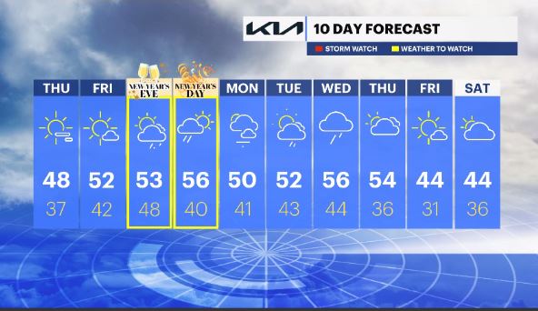
20ds agoWHAT'S NEW: The potential for showers this coming weekend, New Year's Eve & Day, is running higher for Saturday than Sunday. This system looks to exit the region Sunday midday.
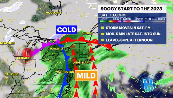
WHAT'S NEXT: The dry stretch of weather we have been enjoying recently, will continue into Friday, which will be delightful and it's the "Pick of the Week."
Storm Watch Team Meteorologist Addison Green says pleasant weather is here for the rest of the workweek but rain is possible for the weekend.
FORECAST:
OVERNIGHT: A few passing clouds with a very light to calm wind. Feels Like: low 30s. Avg. Low: 27. Lows: low 30s.
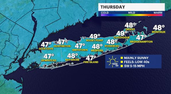
THURSDAY: Lots of sunshine and a southwesterly breeze . Avg. high: 41. Highs: mid to upper 40s. Lows: mid 30s.
FRIDAY: *Pick of the week* Mainly sunny skies with a light southwest wind. Highs: upper 40s to low 50s. Lows: upper 30s to low 40s.
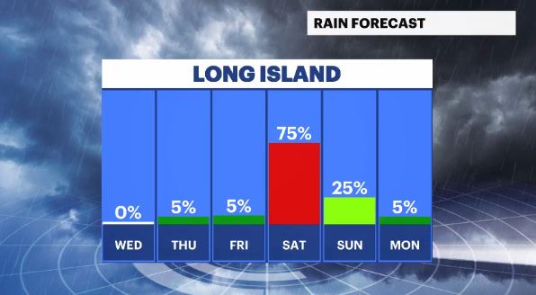
SATURDAY: New Years Eve – WEATHER TO WATCH - Mostly cloudy to overcast in the morning, with a chance for scattered showers for the afternoon/evening hours. Highs: low to mid 50s. Lows: upper 40s.
SUNDAY: New Years Day – WEATHER TO WATCH – Cloudy, damp & dreary with moderate rainfall & breezy winds in the morning then some sun later on. Highs: mid 50s. Lows: low 40s.
MONDAY: Partly cloudy with a northwest breeze. Highs: upper 40s to low 50s. Lows: low 40s.
TUESDAY: Partly cloudy with a chance for showers after sunset. Highs: upper 40s to low 50s. Lows: low 40s.
WEDNESDAY: Cloudy with a chance for rain through much of the day. Highs: mid 50s. Lows: mid 40s.
THURSDAY: Mostly cloudy with rain lingering. Highs: mid 50s. Lows: mid 30s.
FRIDAY: Mostly sunny skies with temps returning to seasonable levels. Highs: mid 40s. Lows: low 30s.